


Atlas Great toursATLAS MOUNTAINS TRAVERSE - 22 DAYS
Tour Details
DAY 1 : Arrival to Marrakech
Arrive in Marrakech and meetyour Guide and transfer to ourhotel or Riad Overnighthotel or Riad.
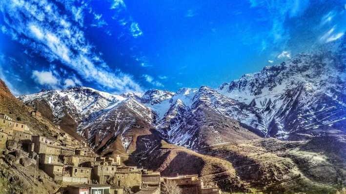
DAY 2 : Tamzrit (2114 metres)
After breakfast wedepart Marrakech and drive eastwards, first through the Central Atlas foothillscrossing the plain of Haouz. At Azilalwe stop for refreshments and thenturnsouthclimbinginto the Ait Bougmez Valley. We arrive at Tamzritwhereweovernight in a Gite or village house or camp. (6 hoursdriving).
DAY 3 : Imi n’ikkis (2350 metres)
Wemeetour team of mules and muleteers and start trekking through a forest of oldoaks. Weclimbpast the village of Arous and up the gorge of the Arous River. A rockypath leads first through box bushes and thenfields of barley, past the occasionalhutwith Jebel Mgoun at the head of the valley. We follow the path to the summergrazingpastures of Imi n’ikkis (2350m). Camp nearImi n’ikkishuts. (3 to 4 hourswalking). Overnight Camp.
DAY 4 : Tarkeddit Plateau (2900 metres)
Fromour camp we continue climbingthrough a magnificentgiant “rockerygarden” landscape. In the spring the hillsides are a riot of colour as yellow and purplebroomburstintoflower. Afterthree to four hours of steadyclimbingwe arrive at the pass of Tizi n-Oumskiyk (3200m), whichprovidestremendousviews of the Mgounpeaks and down to the summergrazingpastures of the Tarkeddit Plateau (2900m). From the passwe descend to the plateau and our camp in the shadow of Jebel Mgoun. (4 to 5 hourswalking). Overnight Camp.
DAY 5 : Optionalascent of Jebel Mgoun (4068 metre)
A day for the optionalascent of Jebel Mgoun (4068m), the only 4000-metre peakoutside of the Toubkal Region. The actualsummitisAmsod (4068m), whichisonly one part of a long ridge, whichstretches for several miles at around 4000 metres. Wemake an early start in the cool of the morning for the 4-hour climb to the ridge. First we cross the Tarkeddit Plateau beforeascendingscree and rock slopes to the summitridge. It isthen a furthertwohoursalong the ridgebeforereaching the summit. There are superbviewsfrom the ridge and from the summit. Look out for the fossilseashells on the final slope. This is a long day, 10 to 12 hoursroundtrip but we are rewardedwith a magnificentwalk and superbviews of multi-coloured mountains and hills. To the east the Toubkal peaks can beseenwhile to the south the large town of Ouazarzate can bepicked out alongwith the huge barrage, the Dades Valley and the Jebel Sahro range stretching towards the Sahara. (10-12 hourswalking). Overnight Camp.
DAY 6 : Tessaout Valley (2220 metres)
The first part of todayswalkis to cross the Tarkeddit Plateau fromeast to west, following the stream, whichis the source of the Tessaout River. After passing a natural rock archwebeginclimbinggraduallythrough a beautifulrockylandscape, dottedwithshepherdshuts to Jebel Tarkeddit (3200m) and the end of the high plateau. Fromherewe descend a rockypathtowards the Tessaout River and the village of Tessaout. As we descend wepasswitheredoldjunipertreeswhile the vegetationalongside the river islush and green. We continue down by Asdrem to reach camp near the end of the Tessaout Gorge (2220m). (6 hourswalking). Overnight Camp.
DAY 7 : Megdaz (2000 metres)
Todays route follows the river all day, throughstark, rocky terrain, whichcreates a feeling of otherworldliness. The descenttakes us through the villages of Amezri and Ichbakenewithsomefinelyperchedhouses. You may have to cross the river and irrigation channels several times today, so carry yoursandals. After lunch continue via the village of Ait Hamza, which has an interestingwatermillbeside the path, to reach Ait Ali Nito. Hereweleave the Tessaout Valley and turnsouthawayfrom the main valley and ascend a jeep track to reach the walnutgroves of the village of Megdaz (2000m) and camp. (6 to 7 hourswalking). Overnight Camp.
DAY 8 : Tamzrit (2200 metres)
Megdazis one of the most attractive Berber villages in the entire Atlas range. Herewevisit Berber homes and the local school if open. We continue climbinggradually, through multi-coloured hillsides to Tizi n’ Megdaz, whichprovidesstunningviews back towards the Mgoun massif.
Our trail ahead can bepicked out towards the peak of Jebel n’Anghomer. The descent to the Taggourt Valley (200m) isthroughbarleyfields, farmed by the people fromMegdaz. We continue down the Taggourt Valley, following the streambed to the point where the valleybecomes a craggy gorge. Hereweleave the valley and beginclimbing to the Fedrhate Plateau.
We cross a series of ridges and climbthrough a hillside of oldoaktrees. The colour of the hillsidesisconstantlychangingfromred to brown to green to black and all shades in-between. From the Tizi n’FedratPasswe descend to cross the road comingfrom Demnate beforeclimbinggradually to the Tamzritsprings (2200m) and our camp. (8 to 9 hourswalking). Overnight Camp.
DAY 9 : Anfergal (1980 metres)
From camp itis a steadyclimb of one hour to the AnghomerPass (Tizi n’Timlilt, 3100m) and tremendousviewssouthtowardsOuazarzate and the Jebel Sahro range. The path continues to climbsteadilyacross the hillsidebeforedescendingsteeply on scree to the valleyfloor, a rockyriverbed. At the end of thisvalleyis a naturallake. The lake’s water isclear and refreshing and containsfish. Herewewill stop for lunch with time to relax and wash!After lunch we descend through a “grand canyon” style landscape of sandstonecliffs and caves. If we are luckywewill spot groundsquirrels as we descend. Fromhereitis an easy 2 to 3 hourwalk to the green pastures of Anfergal and our camp. (4 to 5 hourswalking). Overnight camp.
DAY 10 : Telouet (1900 metres)
The trail follows the path to Animiter, passing over a grassy plateau, whichoverlooks the Telouet Valley. We camp in a smallgrassysidevalley. In the afternoonthereis time to explore the town of Telouet and the Kasbah of the Glaoui Family. (3 to 4 hourswalking). Overnight Camp.
DAY 11 : Adrar Mahboub (2650 metres)
Walking pastsmall villages we cross to the opposite side of the valley and follow a watercoursethrough a ravine, which opens out onto a high grazing area. Our path contours around a ridge to reachour camp high on the flanks of Adrar Mahboubwithsuperbviewssouthtowards the Sahara. (4 to 5 hourswalking) Overnight Camp.
DAY 12 : Azgour (1450 metres)
Today’swalkisincrediblyvaried and we start by dropping down to the Tizi-n-Tichka highway, one of onlytworoadsthatpass the entire Atlas Range. We enter the Tichka Gorge withits black rock scenerybeforeclimbing to the head of the broad, green, enchantingAfra Valley, nestled at the foot of the ArdrarTircht (3578m). Our camp isbeside the river near the village of Azgour (1450m). (7 to 8 hourswalking). Overnight Camp.
DAY 13 : Azgour (1450 metres)
At last, a welldeservedrestday. Our camp is in a lovely location and thereiseveryopportunity for washing and relaxing. Overnight Camp.
DAY 14 : Yagour Plateau (2300 metres)
Our route climbssteeplyalong a mule track onto the Yagour Plateau, passing shepherdssummerhuts and a smalltarn. This area iswellknown for rock carvings and etchings and weshouldbe able to seethesealongour route. We camp on thisfantastic high pasturethat has been used for centuries as summergrazing. (6 to 7 hourswalking). Overnight Camp.
DAY 15 : Timichi (2050 metres)
Todaybeginswith a climb to cross the Tizi-n-Ghell (2330m), whichprovides more wonderfulviews of the High Atlas peaks. We descend into the Ourika Valley, whichwenow follow to the busypilgrimage centre of SettiFadma, a stragglyriverside village, set withgrassyterraces and a backdrop of High Atlas peaksrising on threesides to over 3600m. We continue upstreamthroughsteeplyterracedfields of the Ourika Valley to our camp at Timichi (2050m). (9 to 10 hourswalking). Overnight Camp.
DAY 16 : Ouanesekra (2300 metres)
A long, slow climb to cross the Tizi-n-Tacheddirt (3172m), a passbetween the summits of Bou Igeunouane (3615m) and Angour (3616m), taking us into the Imenane Valley. There is time to enjoy the fantasticscenerybefore an easydescent to our camp near to Ouanesekra (2300m). (7 to 8 hourswalking). Overnight Camp.
DAY 17 : Aroumd (2000 metres)
We cross the Tizi n-Tamatert (2279m) passbeforedescendingsteeply on a zigzag trail into the Mizanevalley to the village of Tamatert. Fromhereitisaround 40 minutes to the large village of Imlil. Imlilis a busy and colourfultrailheadwithplenty of cafes. Here the Mizane River supports a thriving rural community, as their extensive cultivations and terracedfieldsindicate. Centuries of laborious irrigation by the Berbers have resulted in theseterraces and walnuttreesgrowingamong the barren rocks. FromImlilweascend on a zigzag pathtowards the Kasbah du Toubkal. This wasused as a Tibetan temple in Kundun, the movie about the Dalai Lama. It isnow a hotel. Our pathclimbsthroughgroves of walnuttrees and crosses a bridge to join a dirt road, whichwe follow to Aroumd, the highest permanent settlement in the valley (5 to 6 hourswalking). Overnight camp or village accommodation.
DAY 18 : Neltner Refuge (3207 metres)
An early start for the long, slow ascent to the Neltner Refuge (3207m), the base camp for Mount Toubkal, the highestpeak in North Africa. Leaving the green fields of Aroumdwe follow the Mizanevalleypast the holyshrine of Sidi Chamharouch, a place of pilgrimage for manyMoroccans. We must respect the local customs and non-Muslims are not allowed to enter the shrine. There are a number of small shops wherewe can purchaserefreshments. After a picnic lunch by the river we continue the climb to the Neltner Refuge. Overnight camping nearNeltner Refuge (3100m). (7 hourswalking). Overnight camp.
DAY 19 : Ascend Mount Toubkal (4167 metres), return to Neltner Refuge / Aroumd (2000 metres)
The ascent of Mount Toubkal (4167m) istechnicallystraightforwardalthough the loose scree and the altitude make the goingquitetiring. The climb to the summittakes about three and a halfhoursfromourcampsite. After an early breakfast we set off traversing over grass and rocks, then a short scree scramble leads up to the base of the South Cwm. We continue the ascent to Tizi-n-Toubkal (3941m), and then traverse a risingcrest to the summit plateau and the metaltripod, which marks Toubkal’ssummit. Mount Toubkal is the highestpeak in the High Atlas and North Africa at 4167 metres. The viewsfromhere are magnificent, an unobstructedview in every direction. To the northeast are views of the High Atlas and to the south lies the Anti Atlas and the Sahara. We have time to savour the summitviewsbeforedescending to the Neltner Refuge. Herewetake a rest and have lunch beforedescending the valley to Aroumd. (8 to 10 hourswalking). Overnight camp or village accommodation.
DAY 20 : Marrakech (450 metres)
It is a short walk down to Aroumd and Imlil for the drive back to Marrakech (1.5 hours) wherewe check in to ourhotel. The afternoonis free for sightseeing or relaxing by the pool. It iswellworthspendingsome time in the Djemma-el-Fna, the busy main square of Marrakech. Eacheveningthis large open square becomes the main focus of attraction as acrobats, musicians, snakecharmers, water sellers and storytellersbegintheirevening performance. Cafes and restaurants surround the square and many people choose to eat in one of these or from one of the manybarbeques and foodstallsoffer all kinds of mouth-wateringfoodincludingfish and chips, kebabs and chicken. Overnighthotel.
DAY 21 : Marrakech
A free day for sightseeing and shopping. The souqs (markets) of Marrakech are particularly good for productsthat are made of wood and leather, but youwillfindplenty of interesting items including dates and walnuts. You maywish to return to the Djemma El Fna, the central square in the city, which at night takes on vibrancy and personalitythatis unique in the world. Overnighthotel.
DAY 22 : Depart Marrakech
Transfer to the airport for your flight back to your home land.
End of myservice Ihopedidyouspendnice time withmy teams

